
Conservation challenge at the agricultural frontier: deforestation, fire, and land use dynamics in Mato Grosso
Abstract
Achieving conservation objectives within the rapidly changing agricultural frontier in Mato Grosso State requires tradeoffs between production and preservation. We provide a description of deforestation, fire, and land use dynamics during 2000-2005 to consider a range of strategies for conservation planning. Long-term conservation of Cerrado, transition forest, and Amazon biomes in the state can benefit from direct consideration of landscape structure, duration of post-clearing land use, and the mosaic of land uses surrounding potential conservation corridors or reserve areas. Although the creation of new protected areas may not be feasible, since few large, uninterrupted forest areas exist within the state, some conservation objectives can be met through greater coordination of the legal reserve system among property owners. We present three examples of landscape-level prioritization based on existing Forest Code regulations stipulating 80% forest reserves on private property. Through a state mediated system, property owners could augment existing reserve areas on their property through purchase of lands in: 1) buffers surrounding existing conservation units and indigenous reserves; 2) small watersheds with little or no deforestation; 3) forest patches with high connectivity within specified mosaics of different land uses. Any final approach for property-level coordination will depend on the specific conservation goals (e.g., river corridors, bird habitat, or plant biodiversity), but we provide a framework for developing and implementing a conservation plan at the agricultural frontier. Tradeoffs in both conservation value and productive use are required to achieve coordinated conservation at scale.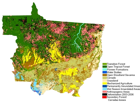
Published
25/06/2007
Issue
Section
Papers
Authors maintain the copyrights for their work. However, they grant rights of first publication to Ambiente e Agua - An Interdisciplinary Journal of Applied Science. In compensation, the journal can transfer the copyrights, allowing non-commercial use of the article including the right of sending the article to other data bases or publication media. The journal uses the CC BY 4.0 license"
