
Archivos - Página 2
-
 Vol. 14 Núm. 5 (2019)
These maps show the distribution of heavy rainfall in Brazil based on a 5-year return period. These results were obtained from IDF (intensity-duration-frequency of heavy rain) relationships of gauge stations in the Brazilian territory. The map in the top left shows heavy rainfall with 5-minute duration. The one to the right shows 30-minute duration. The one at the bottom left shows 60-minute duration and the last one to the right 120-minute duration. According to these results, the highest values are concentrated in the Amazon region and in the southern part of the country and the lowest in the semi-arid region in the northeast. These estimates are important for the design of micro-drainage structures preventing them from being damaged by heavy rainfall events.
Source: SOUZA, G. R. de. et al. Heavy rainfall maps in Brazil to 5 year return period. Rev. Ambient. Água, Taubaté, vol. 14 n. 5, p. 1-10, 2019. doi:10.4136/ambi-agua.2403
-
 Vol. 14 Núm. 4 (2019)
With the goal of assessing possible impacts of fish farming in great-volume cage systems on the water quality of a reservoir, the authors provided abiotic data from 72 samples obtained before and after farming site implementation. The figure shows the principal components analysis results for seven limnological variables. The highest dissolved oxygen (OD) concentrations were observed before the fish farm became operational. During the post-production period, the highest phosphorous (PT) and ammonium (NH4) concentrations were observed as well as high conductivity and turbidity values. Authors concluded that fish farming in cage systems located in Solteira Island Reservoir, Brazil, caused significant temporal and sudden spatial changes in water physical and chemical variables.
Source: ROSINI, E. F. et al. Water quality in Ponte Pensa Aquaculture Park, Solteira Island Reservoir, SP, Brazil, where fish are cultivated under great-volume cage system. Rev. Ambient. Água, Taubaté, vol. 14 n. 4, p. 1-14, 2019. doi:10.4136/ambi-agua.2382
-
 Vol. 14 Núm. 3 (2019)
This research is based on the evidence that the extract of Moringa Oleífera Lam has shown excellent performance for water clarification, reaching 90-94% of turbidity removal. In order to verify such potential, this study focused on applying a hybrid treatment system to the removal of reactive dye Blue 5G from aqueous solutions. This figure shows the surface response for the concentration of residual iron. This surface shows that the lowest values for the concentration of residual iron are achieved when a high dose of aqueous extract of Moringa Oleífera Lam is used and low values of electric current intensity are employed.
Source: SANTOS, B. S. de. et al. Continuous electrochemical reactor improved by the addition of Moringa oleífera lam extract: optimization of operational conditions for Blue 5G dye removal. Rev. Ambient. Água, Taubaté, vol. 14 n. 3, p. 1-14, 2019. doi:10.4136/ambi-agua.2290
-
 Vol. 14 Núm. 2 (2019)
In a review about the use of isoscapes for natural resource management in the Brazilian context, which has high biological diversity and landscape heterogeneity, the authors present this figure that shows mean annual precipitation δ18O (A) and δ2H (B) isoscapes. As this figure presents, the average rates show a significantly lower spatial variation in comparison to temporal and spatial fluctuation found by other studies at a state level. Therefore, developing precipitation isoscape models specific for Brazil is imperative, since current global models mask part of the natural variations of isotopic ratios.
Source: SENA-SOUZA, J. P. et al. Background and the use of isoscapes in the Brazilian context: essential tool for isotope data interpretation and natural resource management. Rev. Ambient. Água, Taubaté, vol. 14 n. 2, p. 1-27, 2019. doi:10.4136/ambi-agua.2282
-
 Vol. 14 Núm. 1 (2019)
The figure shows the resulting morphometric characterization of Peixe river watershed derived from different digital elevation models generated from five elevation data sources (three from SRTM 90-meter resolution data and two from 1:100.000 scale topographic maps). Results indicated that SRTM-O, SRTM-TR, and CT-TR provided the incorrect generation of hydrography in the region of the São Franciscana Depression (flat region), observed by the diversion of main river and generation of the mouth in another basin, causing significant errors in the determination of the morphometric characteristics of the basin, mainly in the drainage area and length of the main river. On the other hand, SRTM-TRH and CT-TRH presented excellent performance and are indicated for on-site study.
Source: FICHER, K. N. et al. Assessment of digital elevation models to obtain morphometric characteristics in relief transition region. Rev. Ambient. Água, Taubaté, vol. 14 n. 1, p. 1-14, 2019. doi:10.4136/ambi-agua.2280
-
 Vol. 13 Núm. 6 (2018)
These maps show the variation of EI30 index that was computed as the product of total kinetic rainfall energy (EC) and maximum 30-min precipitation intensity (I30) in Mato Grosso State, Brazil. During the first and second EI30 periods (October-November and December-March, respectively) many agricultural activities occur in the State. The most critical period is October to February when activities such as tilling, sowing, and harvesting are concentrated. The third period (April-September) is the least critical because the majority of the soils are covered by the crop canopy.
Source: RAIMO, L. A. D. L. D. et al. Spatio-temporal variability of erosivity in Mato Grosso, Brazil. Rev. Ambient. Água, Taubaté, vol. 13 n. 6, p. 1-14, 2018. doi:10.4136/ambi-agua.2276
-
 Vol. 13 Núm. 5 (2018)
Domestic wastewater COD (Chemical Oxygen Demand) elimination using electrocoagulation is influenced by changes in current intensity, pH conditions and time. A three-dimension graphic visualization of the combination of two of these factors at a time is presented in this figure. Authors claim that this technique is more effective than biological processes for the removal of COD from domestic wastewater.
Source: ASCÓN, E. A. A. Elimination of chemical oxygen demand from domestic residual water by electrocoagulation with aluminum and iron electrodes. Rev. Ambient. Água, Taubaté, vol. 13 n. 5, p. 1-16, 2018. doi:10.4136/ambi-agua.2240
-
 Vol. 13 Núm. 4 (2018)
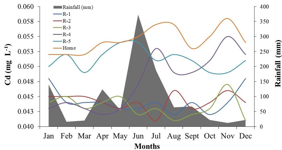
This graph shows the influence of rainfall on the seasonal variation in cadmium (Cd) concentration in water samples from five reservoirs (R) and an artesian well (home). Intensive farming using agrochemicals (fertilizers and pesticides) can increase heavy metal concentrations in the soil-water-plant system, especially in the case of elements poorly retained by the soil and easily lost to leaching.
Source: SILVA, L. S. et al. Heavy metals in waters used for human consumption and crop irrigation. Rev. Ambient. Água, Taubaté, vol. 13 n. 4, p. 1-10, 2018. doi:10.4136/ambi-agua.1999
-
 Vol. 13 Núm. 3 (2018)
These maps show the results of applying inverse distance weighting (IDW) interpolation technique of temperature (A), pH (B) and total dissolved solids -TDS (C) against the distribution of breeding sites and water reservoirs to determine how susceptible these areas were for schistosomiasis intermediate hosts colonization.
Source: BARBOSA, C. S. et al. Insalubrious touristic environments and schistosomiasis transmission in Pernambuco, Brazil. Rev. Ambient. Água, Taubaté, vol. 13 n. 3, p. 1-10, 2018. doi:10.4136/ambi-agua.2151
-
 Vol. 13 Núm. 2 (2018)
Map showing an area in central Mato Grosso State, Brazil, where albedo variation values of forest, burned vegetation, water, and crop areas were analyzed in this Amazon-Cerrado transition zone.
Source: FARIA, T. O. et al. Surface albedo in different land-use and cover types in Amazon forest region. Rev. Ambient. Água, Taubaté, vol. 13 n. 2, p. 1-13, 2018. doi:10.4136/ambi-agua.2120
-
 Vol. 13 Núm. 1 (2018)
Maps showing adequate areas for the cultivation of two varieties of eucalyptus obtained by the application of the Multi-Objective Land Allocation (MOLA) tool.
Source: FRAGA, M. S. et al. Climatic zoning for eucalyptus cultivation through strategic decision analysis. Rev. Ambient. Água, Taubaté, vol. 13 n. 1, p. 1-13, 2018. doi:10.4136/ambi-agua.2119
-
 Vol. 12 Núm. 6 (2017)
Maps of the upper Stör catchment including general location (A), elevation with gauging stations (B); soil (C); and land use (D).
Source: POTT, C. A. et al. Best management practices to reduce nitrate pollution in a rural watershed in Germany. Rev. Ambient. Água, Taubaté, vol. 12 n. 6, p. 888-901, 2017. doi:10.4136/ambi-agua.2099
-
 Vol. 12 Núm. 5 (2017)
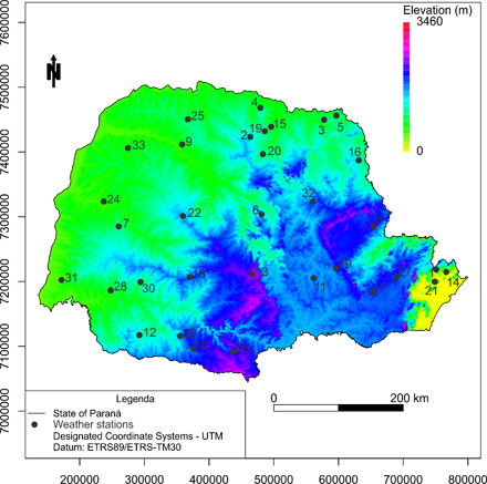
Altitude and distribution of weather stations in the state of Paraná, Brazil
Source: SANTOS, L. C. et al. Space-time variability of evapotranspiration and precipitation in the State of Paraná, Brazil. Rev. Ambient. Água, Taubaté, vol. 12 n. 5, p. 743-759, 2017. doi: 10.4136/ambi-agua.2057
-
 Vol. 12 Núm. 4 (2017)
ASTER digital elevation model for the Tocantins State and spatial distribution of the rainfall stations used in the present study
Source: SILVA NETO, V. L. et al. Daily rainfall disaggregation for Tocantins State, Brazil. Rev. Ambient. Água, Taubaté, vol. 12 n. 4, p. 605-617, 2017. doi: 10.4136/ambi-agua.2077
-
 Vol. 12 Núm. 3 (2017)
Spatial distribution of hydrological stations and watersheds studied in La Guajira Peninsula (Colombia)
Source: DOMÍNGUEZ CALLE, E. A. et al. Objective assessment of ecosystem hydrological services in tropical areas: A Colombian experience in arid and semi-arid zones. Rev. Ambient. Água, Taubaté, vol. 12 n. 3, p. 365-379, 2017. doi: 10.4136/ambi-agua.2098
-
 Vol. 12 Núm. 2 (2017)
Influence of relief on H2S dispersion.
Source: AUGUSTO, M. R.et al. Simulação numérica da dispersão do sulfeto de hidrogênio emitido por um reator UASB para tratamento de esgoto doméstico. Rev. Ambient. Água, Taubaté, vol. 12 n. 2, p. 215-225, 2017. doi: 10.4136/ambi-agua.1841
-
 Vol. 12 Núm. 1 (2017)
Test site to for the geo-inspired model of natural vector multi-agents corresponding to La Perdiz River Basin, Florencia city, Colombia.
Source: MILLAN ROJAS, E. E. et al. Natural vector multi-agents geo-inspired in environmental management. Rev. Ambient. Água, Taubaté, vol. 12 n. 1, p. 47-56, 2017. doi: 10.4136/ambi-agua.1912
-
 Vol. 11 Núm. 5 (2016)
Protocolo de avaliação rápida de pontos da bacia hidrográfica. Trechos impactados: 0 a 25 pontos; trechos alterados: 26 a 40 pontos e trechos naturais: 41 a 60 pontos.
Source: BAIÃO, C.F.P. et al. Avaliação de bacia hidrográfica por alunos do Ensino Fundamental: contribuição ao ensino dos recursos hídricos. Rev. Ambient. Água, Taubaté, vol. 11 (suplemento), p. 1056-1068, 2016. doi: 10.4136/ambi-agua.1895
-
 Vol. 11 Núm. 4 (2016)
Domain of models: (a) global HadGEM2 (resolution 140 x 208 km) and (b) regional RegCM4 (resolution 28 x 28 km) of tropical South America with emphasis on (c) the Brazilian Amazon region. Colors represent the topography (m) and blue contours show the hydrology (main rivers).
Source: ROSA, A.G.et al. Erosividade da chuva em Rondon do Pará, PA, Brasil de 1999 a 2015 e projetada para 2035. Rev. Ambient. Água, Taubaté, vol. 11 n. 4, p. 1006-1021, 2016. doi:10.4136/ambi-agua.1956
-
 Vol. 11 Núm. 3 (2016)
Bathymetry used in computational modeling of the Santos Estuarine System water renewal.
Source: ROVERSI, F. et al. Análise da renovação das águas do Sistema Estuarino de Santos usando modelagem computacional. Rev. Ambient. Água, Taubaté, vol. 11 n. 3, p. 566-585, 2016. doi:10.4136/ambi-agua.1770
-
 Vol. 11 Núm. 2 (2016)
Topographic gradient of the Brazilian Pantanal.
Source: SILVA, M. G. et al. Análise da influência de parâmetros ambientais no fluxo de metano em áreas alagáveis e lagoas permanentes na região do Rio Abobral, no Pantanal, Brasil. Rev. Ambient. Água, Taubaté, vol. 11 n. 2, p. 327-338, 2016. doi:10.4136/ambi-agua.1775 -
 Vol. 11 Núm. 1 (2016)
Electronic photomicrographs of surface scan of: a) sugarcane bagasse and b) activated carbon; both magnified to 1.0 kX. Comparison between the retention of microcystin-LR by sugarcane bagasse and by activated carbon in natura applied as a bio-adsorbent in drinking waters.
Source: ALMEIDA, A. R. et al. Remoção de microcistina-LR da Microcystis aeruginosa utilizando bagaço de cana-de-açúcar in natura e carvão ativado. Rev. Ambient. Água, Taubaté, vol. 11 n. 1, p. 188-197, 2016. doi:10.4136/ambi-agua.1785 -
 Vol. 10 Núm. 4 (2015)
Land use and land cover classes and points of extraction of biophysical indexes of Puruzinho River Basin in the southwest of the Brazilian Amazon.
Source: TARTARI, R. et al. Análise de índices biofísicos a partir de imagens TM Landsat 5 em paisagem heterogênea no Sudoeste da Amazônia. Rev. Ambient. Água, Taubaté, vol. 10 n.4, p. 943-953, 2015. http://dx.doi.org/10.4136/ambi-agua.1663 -
 Vol. 10 Núm. 3 (2015)
Sampling area and sampling sites, five sites located upstream and three downstream of the Santo Antônio's Hydroelectric Dam, Rondônia, Brazil.
Source: SOUSA, E. A. et al. Assessment of trace metals in Amazonian fish exposed to untreated urban sewage: high chromium concentrations in fish tissues. Rev. Ambient. Água, Taubaté, vol. 10 n. 3, p. 499-509, 2015. doi:10.4136/ambi-agua.1594
-
 Vol. 10 Núm. 2 (2015)
Landsat 5 image, day 28/07/2009, bands 5, 4, and 3 (RGB). The color pink represents pasture and cropland. Soybean and rice croplands fields in the east of the image.
Source: OLIVEIRA JUNIOR, R. C. et al. Chemical analysis of rainfall and throughfall in the Tapajós National Forest, Belterra, Pará, Brazil. Rev. Ambient. Água, Taubaté, vol. 10 n. 2, p. 263-285, 2015. http://dx.doi.org/10.4136/ambi-agua.1552
