
Methodology for generation of hydrogeologic maps: rio da Palma watershed case study, DF, Brazil
Abstract
This paper had the objective of developing a methodology to support the management of water resources, based on hydro geological cartography, tested for the hydro geologic conditions of a watershed located at Central Brazil. Results show two major products: a hydro geologic, and a potential infiltration and recharge maps of the high course of the Rio da Palma watershed. This paper is presented in six parts. The first one discusses the map’s elements, essential thematic maps and appropriate scales. The second part proposes the graphic criteria for the integrated representation of the major parameters of overlaying aquifers. The third part demonstrates the importance of the data basis for the hydro geologic cartography, i.e., the contribution of each theme such as soil, geology, slope, climate and land use, when appropriately integrated. The fourth part discusses the selection and the integration of the main information layers for the Rio da Palma watershed using a Geographic Information System (GIS). On the fifth part, the result of the integration of the porous domain with the fractured domain aquifer information layers is shown and, finally, the potential infiltration and recharge map of the studied area, elaborated from the integration of overlapping of the data basis information layers is presented and discussed. In general, in the studied area, regions with high infiltration potential prevail where human interference is still moderate. Large portions of low infiltration potential are either associated with high slopes, with shallow soils (Cambissolos) or else with urban constructions.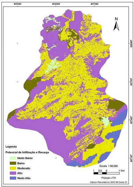
Published
31/08/2007
Issue
Section
Papers
Authors maintain the copyrights for their work. However, they grant rights of first publication to Ambiente e Agua - An Interdisciplinary Journal of Applied Science. In compensation, the journal can transfer the copyrights, allowing non-commercial use of the article including the right of sending the article to other data bases or publication media. The journal uses the CC BY 4.0 license"
