
Mapping and analysis of the groundwater potability in the Lajeado municipality, Rio Grande do Sul State, Brazil
Keywords:
groundwater, microbiological and physico-chemical analysis, potability standards, geoprocessing, geostatistics
Abstract
The groundwater sources spread in extensive areas and are relatively protected from pollution agents when compared to rivers and artificial reservoirs. These aspects, combined with low exploitation costs, provided a considerable growth in the groundwater use in the last decades. Groundwater became an important alternative source for public water supply in Brazil. This paper shows the georeferenced location of the groundwater exploitation points in the Lajeado, RS municipality and the potability analysis of this water. The groundwater exploitation in the study area is accomplished in the Serra Geral and Guarani aquifers and the exploitation points were identified in field campaigns using a GPS receiver and plotted over satellite imagery using remote sensing and geoprocessing techniques. The groundwater potability assessment was based on 100 samples for microbiological and physico-chemical analyses that included 78 samples of tubular wells and 22 of dug wells. Contour maps were generated for the analyzed parameters in the tubular wells, using geostatistics procedures. In this study, 362 tubular wells and 253 dug wells were studied. The results show that the dug wells are located mainly in rural areas and 77.27% of them aren’t suitable for human consumption due to high levels of contamination. The tubular wells are concentrated in urban areas and results revealed that 76.92% of them have water with suitable quality for the human consumption.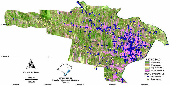
Published
23/04/2009
Issue
Section
Papers
Authors maintain the copyrights for their work. However, they grant rights of first publication to Ambiente e Agua - An Interdisciplinary Journal of Applied Science. In compensation, the journal can transfer the copyrights, allowing non-commercial use of the article including the right of sending the article to other data bases or publication media. The journal uses the CC BY 4.0 license"
